
Kent Cycling and Walking Infrastructure Plan
Update November 2024
The consultation report, along with an update on the Kent Cycling and Walking Infrastructure Plan's (KCWIP) objectives and methodology was presented to Members of the Environment and Transport Cabinet Committee on 19 September 2024.
The Cabinet Member for Highways and Transport has now approved the first version of the KCWIP. This is available with the associated supporting documents, including an executive summary, from the ‘Documents’ section on this webpage.
Update
Thank you to everyone who took part in this consultation. The feedback has been carefully analysed and considered.
The consultation report, along with a 'You Said, We Did' document detailing how responses have helped finalise the Plan, are now available in the 'Documents' section.
The consultation report, along with the final Kent Cycling and Walking Infrastructure Plan (KCWIP), will be presented to Members of the Environment and Transport Cabinet Committee on 19 September 2024.
Update
Thank you to everyone who took part in this consultation. The feedback is being carefully analysed and considered.
A consultation report, along with the final Kent Cycling and Walking Infrastructure Plan (KCWIP), will be presented to Members of the Environment and Transport Cabinet Committee in due course. The consultation report will be made available from this webpage, along with a 'You Said, We Did' document detailing how responses have helped finalise the Plan, and a link to the final KCWIP.
Original consultation content:
Welcome to the public consultation on the proposed active travel network which will form the first Kent Cycling and Walking Infrastructure Plan (KCWIP).
We are carrying out this consultation to gather your views on the proposed cycling routes and walking and wheeling zones to enable residents and visitors to make more journeys on foot or by cycle. Your feedback, local knowledge and insights will be invaluable in understanding the challenges and opportunities for active travel improvements across Kent.
Why do we need a KCWIP?
The government’s ambition is to make walking, wheeling and cycling the natural choices, both for shorter and longer journeys. Transforming local areas in ways that support active travel will reduce congestion, improve air quality, improve physical and mental health and support local economies.
The Local Cycling and Walking Infrastructure Plan (LCWIP) concept has been developed by the Department for Transport (DfT) for local and regional authorities to take a strategic approach in improving walking and cycling infrastructure. We have been working with many of the district councils in Kent to develop detailed LCWIPs and have been successful in obtaining funding for the delivery of some of their proposals in recent years.
To fulfil our county-wide role as the Local Transport Authority, to supplement the existing LCWIPs and to aid future LCWIP development in parts of Kent, we have decided to develop a KCWIP. This is to ensure that the public and stakeholders are clear about where our priorities are for improvements to walking, wheeling and cycling and to help us make sure that each district LCWIP forms a coherent county wide plan for delivery.
What will the KCWIP deliver?
The key outcomes of the KCWIP are:
- A network plan for walking and cycling, which identifies preferred routes and core walking and wheeling zones.
- A plan for integrating the KCWIP into active travel planning policies, strategies, and delivery plans.
- A prioritised programme of infrastructure improvements for future investment.
- A robust, evidence-based document which sets out the underlying analysis conducted and provides a narrative which supports the identified improvements and network.
How can I find out more?
Please read / view the information provided on this web page before you take part in the consultation. You can:
- Watch the short video to find out more about the KCWIP background and methodology.
- Read the Consultation Document to find out more about the KCWIP and proposals.
- View the interactive maps or individual scheme plans to see the proposed cycle routes and walking and wheeling zones. These maps provide an indication of the types of improvements that could be developed for each route or zone.
- Take a look at the summary 'tube style' maps for the cycle routes showing the key destinations along each route.
- Use the Question and Answer tool below.
How can I get involved?
There are a number of ways to get involved:
- Use our interactive maps below to comment on specific locations and improvements.
- Complete the consultation questionnaire to help us further understand your views on the proposed cycle routes and walking and wheeling zones and their respective improvements.
- Come and meet us at one of our in person public drop-in events;
- 8 November 2-7pm Union Street Methodist Church, 20 Brewer Street, Maidstone, ME14 1RU
- 13 November 2-7pm Cyclopark, Watling Street, Gravesend, DA11 7NP
- 16 November 2-7pm The Guildhall, St Peter’s Pl, Westgate, Canterbury, CT1 2DB
If you can’t attend an in person event, use the Question and Answer tool below or contact us using the details on this webpage.
What happens next?
Once your feedback reaches us, we will:
- Analyse responses to this consultation and produce a Consultation Report, which will be published on this webpage.
- Where possible, incorporate feedback from the consultation and amend the cycling routes and walking and wheeling zones.
- Prioritise the cycling routes and walking zones and their respective improvements in the short, medium and long term to produce a prioritised programme of cycling and walking infrastructure improvements.
- Present the final KCWIP to the Environment and Transport Cabinet Committee. Once approved the Plan will be integrated into local policies, strategies and plans.

Video - find out more about the KCWIP background and methodology

Documents
-
 Full Kent Cycling and Walking Infrastructure Plan (this is a large document which may take some time to open) (28.1 MB) (pdf)
-
Executive Summary of the KCWIP (6.91 MB) (pdf)
-
Appendix A - Consultation Report (6.14 MB) (pdf)
-
Appendix B - Cycling Routes (this is a very large document which may take some time to open) (128 MB) (pdf)
-
Appendix C - Walking Zones (this is a large document which may take some time to open) (84.1 MB) (pdf)
-
Appendix D - Prioritisation and Intervention Costs (84.7 KB) (pdf)
-
Consultation Report (6.14 MB) (pdf)
-
You Said We Did (256 KB) (pdf)
-
Consultation Document (1.54 MB) (pdf)
-
 15 proposed cycling routes
-
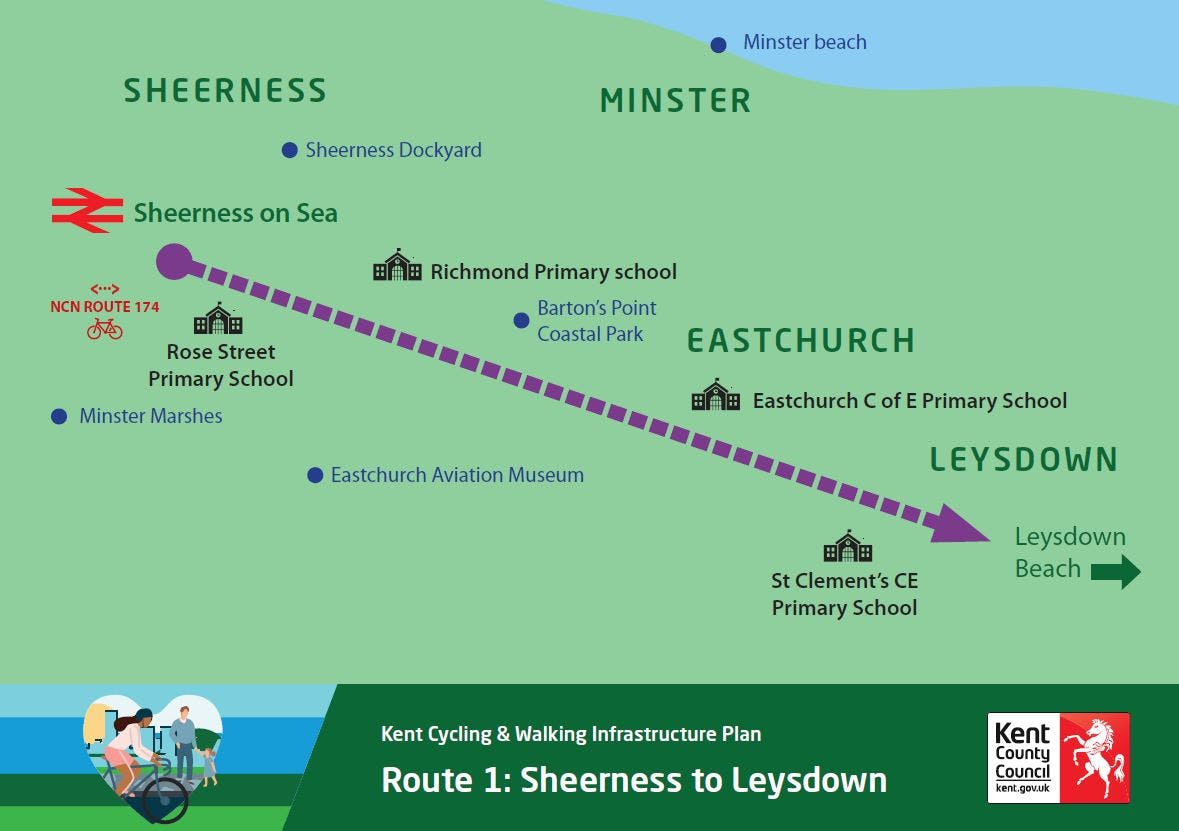
R1 Sheerness to Leysdown-on-Sea (1.5 MB) (pdf)
-
R2 Gravesend to Dartford (3.96 MB) (pdf)
-
R3 Canterbury to Dover (3.27 MB) (pdf)
-
R4 Canterbury to Folkstone (3.33 MB) (pdf)
-
R5 Sittingbourne to Faversham (2.06 MB) (pdf)
-
R6 Birchington to Ramsgate (2.84 MB) (pdf)
-
R7 Dover to Deal (1.75 MB) (pdf)
-
R8 Ashford to Folkestone (3.2 MB) (pdf)
-
R9 Canterbury to Sand (3.63 MB) (pdf)
-
R10 Dartford to Stone (2.03 MB) (pdf)
-
R11 Ashford to Charing (2.01 MB) (pdf)
-
R12 Canterbury to Birchington (2.3 MB) (pdf)
-
R13 Folkestone to Hythe (1.9 MB) (pdf)
-
R14 Maidstone to Sittingbourne (3.91 MB) (pdf)
-
R15 Gravesend to Meopham (3.15 MB) (pdf)
-
Alt Text for all 15 cycle routes (40.6 KB) (docx)
-
-
15 proposed walking and wheeling routes
-
01 Dover (1.65 MB) (pdf)
-
02 Canterbury (2.02 MB) (pdf)
-
03 Sittingbourne (2.36 MB) (pdf)
-
04 Stone (3.81 MB) (pdf)
-
05 Swanley (2.43 MB) (pdf)
-
06 Dartford (4.24 MB) (pdf)
-
07 Herne Bay (1.37 MB) (pdf)
-
08 Margate to Ramsgate Corridor (1.96 MB) (pdf)
-
09 Herne (1.4 MB) (pdf)
-
10 Swanscombe (4 MB) (pdf)
-
11 Whitstable (1.59 MB) (pdf)
-
12 Deal (1.47 MB) (pdf)
-
13 Southborough (2.19 MB) (pdf)
-
14 Tonbridge (2.06 MB) (pdf)
-
15 Birchington (1.38 MB) (pdf)
-
Alt Text for all 15 walking routes (26.3 KB) (docx)
-
-
Equality Impact Assessment (212 KB) (pdf)
-
Plans featured in the Consultation Document
-
Map 1 Classified cycling routes (page 8) (5.81 MB) (pdf)
-
Map 2 Classified walking wheeling zones (page 9) (1.54 MB) (pdf)
-
Map 3 Primary desire lines converted into routes (page 10) (6.04 MB) (pdf)
-
Map 4 Proposed cycle routes (page 13) (1.58 MB) (pdf)
-
Map 5 Proposed walking and wheeling zones (page 16) (1.56 MB) (pdf)
-
-
Route and Zone Scoring
-
Large print documents


Video - find out how to use the interactive maps

Proposed cycle routes with key destinations
Who's listening
-
Kent Highways

Phone 03000 41 81 81 Email activetravel@kent.gov.uk